Badge

Avencia Releases Walkshed NY for NYC BigApps Contest: Web-based Tool Enables Citizens to Generate Walkability Maps of NYC Based on Individual Preferences

Top Quote 
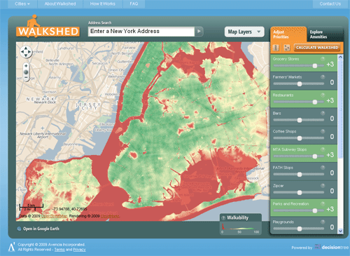
Avencia, a Philadelphia-based geographic analysis and software development firm today released Walkshed New York (NY) - a web application that uses advanced technology to calculate and map walkability based on user preferences. End Quote
    walkshedny
  • New York, NY (1888PressRelease) December 16, 2009 - Avencia, an award-winning, Philadelphia-based geographic analysis and software development firm announces the release of Walkshed New York (NY) – a web application that uses advanced technology to calculate and map walkability based on user preferences. Avencia created Walkshed NY as a submission for the NYC BigApps Contest.

    A City of New York initiative, the contest solicited software application entries that utilize the city’s recently released NYC Data Mine - a repository of location-based data sets from over two dozen city agencies. Winners will be determined by votes from a panel of judges as well as public votes (public voting takes place December 15 – January 7).

    Developed by software developer Aaron Ogle as part of Avencia's 10% research project program, Walkshed NY enables users to make precise and personal walkability calculations for any location in the city. Instead of using "as-the-crow-flies" calculations, Walkshed takes into account the barriers (rivers, highways, etc.) and disconnected street networks that often prevent pedestrians from reaching desirable locations. Walkshed works by using "friction-based" (aka "cost-based") distance calculations in lieu of straight-line distances to reflect the relative ease or difficulty of walking through the streets, and to optimize accuracy. Walkshed friction calculations work by laying a grid of more than 150 million cells over the entire city and determining how much “friction” a pedestrian would encounter for each cell.

    Drawing from several data sources, including NYC Data Mine, Bing and InfoUSA, Walkshed NYC includes 17 decision factors in its walkability calculations, including proximity to subway stops, coffee shops, parks and playgrounds, restaurants and bars, farmer’s markets, grocery stores, cultural centers, libraries, post offices, and bookstores. Users are then able to assign positive or negative weights to each factor in the system.

    For example, one person might define walkability based on living close to a library, a cultural center, and public transit while another person might define it as being close to restaurants and a grocery store. Each of Walkshed NYC’s 17 preferences can be set to 11 values, providing enough choices for each NYC resident to generate 60 billion distinct factor combinations. The complexity only begins there. Each of the 17 walkability preferences are made up of 157,715,256 values arranged in a grid to cover the city. This immense calculation is performed on-demand by DecisionTree®, Avencia’s geographic planning and prioritization software.

    “I’m excited see a staff research project reach the point where it becomes a public resource,” said Robert Cheetham, President and CEO of Avencia. “Personal R&D projects are an important part of Avencia’s culture. They provide both a mechanism for our staff to develop their skills and a way for the company to extend its capabilities into new domains. In the case of Walkshed, Aaron’s work is enabling Avencia to learn more about sustainable transportation systems as well as creating a new demonstration of our DecisionTree technology.”

    Avencia believes that geographic tools, like Walkshed, can promote a more sustainable economy and environment. Planning water sources, land use, optimal public transit routes, better sidewalk networks and bike lanes, traffic light timing, and distance from diverse habitats are just a few of the ways that geographic technology can help make towns and cities operate in a more sustainable manner. The Walkshed application is one example of how Avencia uses DecisionTree® to assist planners, economic development professionals, land conservation specialists, energy analysts, and other sustainability-minded professionals in indentifying the best locations for the specific activities they are involved in - ultimately making our communities healthier, as well as socially and economically responsible.

    About Avencia
    Avencia is an award-winning, Philadelphia-based geographic analysis and software development firm specializing in the creation of innovative location-based software tools to enhance decision-making processes. Avencia believes these location-based technologies can help promote the emergence of more dynamic, vibrant communities.

    For more information, visit http://www.avencia.com

    About NYC BigApps
    A joint project of New York City Economic Development Corporation and the New York City Department of Information Technology & Telecommunications, The NYC BigApps competition “is a City of New York initiative intended to stimulate innovation in the information technology and media industries, and attract and support developer talent to develop web and mobile applications (apps) by using City data. These apps will benefit the City and its citizens and demonstrate the increasing accessibility and transparency of City government.”

    ###
space
space
  • FB Icon Twitter Icon In-Icon
Contact Information
Product Gallery
  • ImageGallery